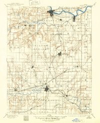
1885 Map of Lawrence
USGS Topo · Published 1957About this map
The Kansas River and Marais des Cygnes River systems anchor this 1885 survey, documenting the early growth of Eastern Kansas before the turn of the century. The map highlights a dense network of competing rail lines, including the Union Pacific Railroad and the Southern Kansas Railroad, which fueled the rise of regional hubs like Ottawa and Baldwin City. Smaller settlements such as Belvoir, Vinland, and Clinton appear as distinct rail stops or rural crossroads, often accompanied by local landmarks like Blue Mound and the Three Sisters. This survey provides a clear view of the late-19th-century landscape where agricultural development was tightly tied to river valleys and the expanding reach of the Atchison Topeka and Santa Fe Railroad.
Find a feature on this map
82 named features on this map. Tap any name to fly to it.
Don’t see what you’re looking for? This feature index may not catch every label — zoom into the map to look around manually.
Map Details
Editions of this 1885 Lawrence Map
This is the sole edition of this map. No revisions or reprints were ever made.
Historical Maps of Lawrence Through Time
7 maps found