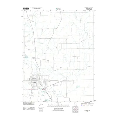
2012 Map of Richmond
USGS Topo · Published 2012About this map
The city of Richmond serves as the central hub of this Missouri landscape, where the street grid is anchored by Richmond Schools and numerous burial grounds including Woodland Cemetery, Shotwell Cemetery, and Sunny Slope Cemetery. To the north, the terrain is defined by the winding paths of the West Fork Crooked River and East Fork Crooked River, which carve through the countryside near the small settlement of Dockery. This 2012 survey illustrates a region where water management is prominent, evidenced by the Ray County Community Lake and various reservoirs like Monomane 171 Reservoir. Local family history is etched across the rural sections, with numerous small plots such as the Wall Cemetery, Johnson Cemetery, and Gunnell Cemetery distributed among the farmland. The presence of Curtis Field and several dams, including the Shirkey Recreation Park Lake Dam, highlights the area's mix of agricultural utility and recreational spaces.
Find a feature on this map
55 named features on this map. Tap any name to fly to it.
Don’t see what you’re looking for? This feature index may not catch every label — zoom into the map to look around manually.
Map Details
Editions of this 2012 Richmond Map
This is the sole edition of this map. No revisions or reprints were ever made.
Other maps of this area

1889 · Lexington
USGS Topo · 1:125,000

1894 · Independence
USGS Topo · 1:125,000

1949 · Lexington East
USGS Topo · 1:24,000

1949 · Lexington West
USGS Topo · 1:24,000

1950 · Lexington East
USGS Topo · 1:24,000

1950 · Kansas City
USGS Topo · 1:250,000
1950 · Camden
USGS Topo · 1:24,000
1950 · Lexington West
USGS Topo · 1:24,000
1951 · Camden
USGS Topo · 1:24,000

1953 · Moberly
USGS Topo · 1:250,000