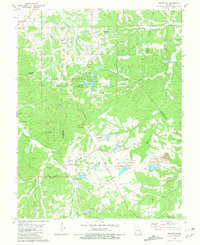
1981 Map of Richwoods
USGS Topo · Published 1981About this map
The Big River carves a winding path through the northeast corner of this landscape, where the borders of Franklin, Jefferson, and Washington counties converge. In the early 1980s, the region was defined by a mix of heavy extractive industry and conservation, with the Little Indian Creek State Forest providing a significant preserve against the industrial footprint of local mining. The community of Richwoods serves as a central hub, surrounded by a complex system of Richwoods Tailings Ponds and active Strip Mines that illustrate the importance of lead or mineral extraction to the local economy.
Find a feature on this map
53 named features on this map. Tap any name to fly to it.
Don’t see what you’re looking for? This feature index may not catch every label — zoom into the map to look around manually.
Map Details
Editions of this 1981 Richwoods Map
This is the sole edition of this map. No revisions or reprints were ever made.
Other maps of this area

1901 · De Soto
USGS Topo · 1:125,000

1937 · Fletcher
USGS Topo · 1:24,000

1937 · Tiff
USGS Topo · 1:24,000

1938 · Cedar Hill
USGS Topo · 1:24,000

1938 · Fletcher
USGS Topo · 1:24,000

1939 · Tiff
USGS Topo · 1:24,000

1940 · Cedar Hill
USGS Topo · 1:24,000

1946 · Richwoods
USGS Topo · 1:62,500

1947 · St. Clair
USGS Topo · 1:62,500

1948 · Richwoods
USGS Topo · 1:62,500