
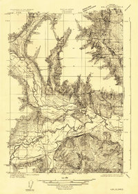
1915 Map of Rickreall
USGS Topo · Published 1915About this map
Rickreall Creek meanders through this portion of Polk County, where the agricultural and rail landscapes of the mid-1910s are intricately documented. The intersection of the Southern Pacific (Westside Division) and the Salem Falls City and Western rail lines at Gerlinger serves as a focal point for the region's transport network. Local education and community life are marked by the Greenwood School and Oakpoint School, while the presence of the Derry Orchard highlights the importance of the area's fruit production. Along the eastern edge, the Willamette River defines the boundary line, winding past Hayden Lake and Humbug Lake. The terrain transitions from the lowlands near Mud Slough to the prominent rise of Bald Hill and the heights near Holmes Gap, providing a clear view of the rural settlement patterns of early 20th-century Oregon.
Find a feature on this map
23 named features on this map. Tap any name to fly to it.
Don’t see what you’re looking for? This feature index may not catch every label — zoom into the map to look around manually.
Map Details
Editions of this 1915 Rickreall Map
This is the sole edition of this map. No revisions or reprints were ever made.
Other maps of this area

1914 · Independence
USGS Topo · 1:31,680

1915 · Eola
USGS Topo · 1:31,680

1915 · Sidney
USGS Topo · 1:31,680

1917 · Salem
USGS Topo · 1:62,500
1922 · Airlie
USGS Topo · 1:31,680

1924 · Mc Minnville
USGS Topo · 1:48,000

1926 · Mc Minnville
USGS Topo · 1:62,500

1940 · McMinnville
USGS Topo · 1:62,500
1940 · Salem
USGS Topo · 1:62,500

1942 · Sheridan
USGS Topo · 1:62,500