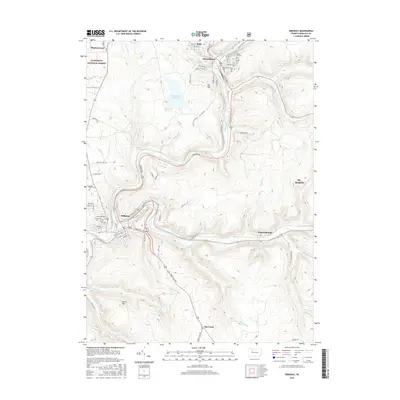
2016 Map of Ridgway
USGS Topo · Published 2016About this map
Ridgway and Johnsonburg anchor this survey of Elk County, Pennsylvania, showing the convergence of the Clarion River and the East Branch Clarion River. The landscape is defined by the steep valley corridors and industrial infrastructure of the Allegheny Plateau, featuring several water management sites like the Bailey Run Reservoir and Sedimentation Reservoir. In Johnsonburg, the street grid climbs toward Dill Hill and is flanked by the Laurel Hill Cem, while to the south, the Ridgway area is dotted with local burial grounds including Saint Leos Cem, Thayer Cem, and Pine Grove Cem. Portions of the Allegheny National Forest reach into the northwestern corner near Montmorenci, while smaller settlements such as Daguscahonda and Boot Jack mark the roadway intersections in the rugged terrain between Elk Cr and Mohan Run.
Find a feature on this map
95 named features on this map. Tap any name to fly to it.
Don’t see what you’re looking for? This feature index may not catch every label — zoom into the map to look around manually.
Map Details
Editions of this 2016 Ridgway Map
This is the sole edition of this map. No revisions or reprints were ever made.
Other maps of this area

1934 · Kane
USGS Topo · 1:48,000

1935 · Mt. Jewett
USGS Topo · 1:48,000

1939 · Kane
USGS Topo · 1:62,500

1940 · Hallton
USGS Topo · 1:48,000

1940 · Mt. Jewett
USGS Topo · 1:62,500

1941 · Ridgway
USGS Topo · 1:62,500

1943 · Hallton
USGS Topo · 1:62,500

1944 · Ridgway
USGS Topo · 1:62,500

1957 · Warren
USGS Topo · 1:250,000

1958 · Warren
USGS Topo · 1:250,000