
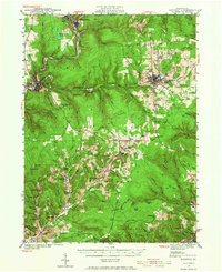
1941 Map of Ridgway
USGS Topo · Published 1956About this map
Ridgway and St. Marys anchor this industrial corridor in Elk County, where the Clarion River and Elk Creek carve through the plateau. Surveyed just before the United States entered World War II, the landscape is defined by its extraction economy and a dense rail network. The Pennsylvania RR and Erie RR connect manufacturing hubs to remote extraction sites like Dagus Mines and Toby Mine.
Find a feature on this map
79 named features on this map. Tap any name to fly to it.
Don’t see what you’re looking for? This feature index may not catch every label — zoom into the map to look around manually.
Map Details
Editions of this 1941 Ridgway Map
2 editions found
Other maps of this area

1922 · Du Bois
USGS Topo · 1:62,500

1924 · Du Bois
USGS Topo · 1:62,500

1929 · Clearfield
USGS Topo · 1:48,000

1929 · Penfield
USGS Topo · 1:62,500

1932 · Clearfield
USGS Topo · 1:62,500

1932 · Penfield
USGS Topo · 1:62,500

1934 · Kane
USGS Topo · 1:48,000

1935 · Mt. Jewett
USGS Topo · 1:48,000

1939 · Kane
USGS Topo · 1:62,500

1940 · Hallton
USGS Topo · 1:48,000