1997 Map of Riegelsville
USGS Topo · Published 1999About this map
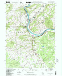
The Delaware River serves as the focal point for this late-1990s geography, where the border between Pennsylvania and New Jersey is defined by the water's path and the adjacent Delaware Canal State Park. The industrial history of the region is anchored by the Durham Furnace near the mouth of Cooks Creek, a site of significant local heritage. The settlement patterns reflect a rural landscape punctuated by small crossroads and river towns, including Riegelsville and Kintnersville. Steep elevations like Hexenkopf Hill and Musconetcong Mountain rise sharply from the valley floor, creating a landscape of high ridges and narrow creek beds. Cultural landmarks are densely distributed throughout, with numerous local institutions such as Durham Union Ch, Marienstein Ch, and Durham Sch serving the community. Large tracts of protected territory, including State Game Lands No 56 and Ringing Rocks County Park, preserve the wooded character of the Bucks County and Northampton County terrain.
Find a feature on this map
78 named features on this map. Tap any name to fly to it.
Don’t see what you’re looking for? This feature index may not catch every label — zoom into the map to look around manually.
Map Details
Editions of this 1997 Riegelsville Map
This is the sole edition of this map. No revisions or reprints were ever made.
Other maps of this area

1888 · Quakertown
USGS Topo · 1:62,500

1890 · Easton
USGS Topo · 1:62,500

1890 · Doylestown
USGS Topo · 1:62,500

1890 · Quakertown
USGS Topo · 1:62,500

1891 · Easton
USGS Topo · 1:62,500

1891 · Doylestown
USGS Topo · 1:62,500

1894 · Allentown
USGS Topo · 1:62,500

1894 · Quakertown
USGS Topo · 1:62,500

1932 · Easton
USGS Topo · 1:62,500

1939 · Allentown
USGS Topo · 1:62,500