Loading...
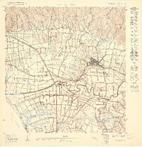
Loading map...1950 Map of Rincon SE
USGS Topo · Published 1950About this map
Agricultural colonias and industrial sugar infrastructure dominate this mid-century landscape around Añasco. The town itself serves as a central hub, linked by the Ferrocarril de Puerto Rico which snakes through the fertile alluvial plains of the Río Grande de Añasco. This era was defined by the transition from traditional haciendas to large-scale industrial centrals, evidenced here by the prominent Central Eureka and Central Igualdad operations.
Find a feature on this map
64 named features on this map. Tap any name to fly to it.
Don’t see what you’re looking for? This feature index may not catch every label — zoom into the map to look around manually.
Map Details
Date Portrayed1950
Date Published1950
PublisherU.S. Geological Survey
Map TypeTopographic
Scale1:10000
Physical Dimensions30.62 x 31.71 inches
Editions of this 1950 Rincon SE Map
This is the sole edition of this map. No revisions or reprints were ever made.
Historical Maps of Rincón Through Time
3 maps found
Featured Locations
Source Details
SourceU.S. Geological Survey
CopyrightPublic Domain