Loading...
Loading map...1950 Map of Central La Plata SO
USGS Topo · Published 1950About this map
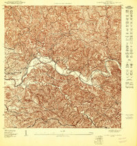
The winding course of the Río Grande de Añasco anchors this mid-century preliminary survey of the Central La Plata region. The landscape is defined by the agricultural heritage of the area, evidenced by the presence of Hacienda El Mato and Hacienda Libertad. The intricate drainage system of the valley is captured in detail through the courses of Quebrada de la Plata, Quebrada Piedras, and Quebrada Chiquita.
Find a feature on this map
19 named features on this map. Tap any name to fly to it.
Don’t see what you’re looking for? This feature index may not catch every label — zoom into the map to look around manually.
Map Details
Date Portrayed1950
Date Published1950
PublisherU.S. Geological Survey
Map TypeTopographic
Scale1:10,000
Physical Dimensions30.5 x 32.4 inches
Editions of this 1950 Central La Plata SO Map
This is the sole edition of this map. No revisions or reprints were ever made.
Historical Maps of Sector La Grúa Through Time
3 maps found
Featured Locations
Source Details
SourceU.S. Geological Survey
CopyrightPublic Domain