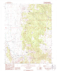
1988 Map of Risue Canyon
USGS Topo · Published 1989About this map
Antelope Valley and the Wellington Hills dominate this late-twentieth-century landscape, straddling the high-elevation boundary between Nevada and California. The Walker River meanders through the western lowlands, where the settlement of Walker and the Camp Antelope athletic field mark the primary human footprint. This area was clearly a site of active resource extraction, as evidenced by numerous prospects and named operations such as the Arrowhead Mine and Lilly Mine scattered across the eastern slopes.
Find a feature on this map
32 named features on this map. Tap any name to fly to it.
Don’t see what you’re looking for? This feature index may not catch every label — zoom into the map to look around manually.
Map Details
Editions of this 1988 Risue Canyon Map
This is the sole edition of this map. No revisions or reprints were ever made.
Other maps of this area

1889 · Markleeville
USGS Topo · 1:125,000

1891 · Markleeville
USGS Topo · 1:125,000

1891 · Wellington
USGS Topo · 1:125,000

1893 · Markleeville
USGS Topo · 1:125,000

1893 · Wellington
USGS Topo · 1:125,000

1896 · Dardanelles
USGS Topo · 1:125,000

1898 · Dardanelles
USGS Topo · 1:125,000

1909 · Bridgeport
USGS Topo · 1:125,000

1911 · Bridgeport
USGS Topo · 1:125,000

1920 · Bridgeport
USGS Topo · 1:125,000