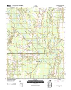
2013 Map of Riverdale
USGS Topo · Published 2013About this map
The confluence of the Nottoway River and Blackwater River forms the headwaters of the Chowan River in this coastal plain landscape along the Virginia and North Carolina border. This riverine network historically supported a bustling timber and agricultural economy, evidenced by numerous landings and wharves such as Cobbs Wharf, Macks Wharf, and Gatlington Landing. Small riverfront settlements like Riverdale, Riddicksville, and Wyanoke are connected by a web of local routes, including Smiths Ferry RD and S Quay RD. The presence of a Brickyard near Mill Neck indicates local industrial activity, while the General Vaughan Bridge serves as a critical crossing point over the Nottoway. Genealogists and local historians can trace family-named landmarks like Georges Bend and Simms Gut, or locate small landings such as Cathole Landing and Milk Landing that were once vital for regional transport.
Find a feature on this map
65 named features on this map. Tap any name to fly to it.
Don’t see what you’re looking for? This feature index may not catch every label — zoom into the map to look around manually.
Map Details
Editions of this 2013 Riverdale Map
This is the sole edition of this map. No revisions or reprints were ever made.
Other maps of this area

1908 · Winton
USGS Topo · 1:62,500

1919 · Boykins
USGS Topo · 1:48,000

1920 · Holland
USGS Topo · 1:62,500

1920 · Boykins
USGS Topo · 1:62,500

1943 · Holland
USGS Topo · 1:62,500

1953 · Norfolk
USGS Topo · 1:250,000

1957 · Holland
USGS Topo · 1:62,500

1966 · Sunbeam
USGS Topo · 1:24,000
1967 · Courtland
USGS Topo · 1:24,000
1967 · Franklin
USGS Topo · 1:24,000