
1957 Map of Holland
USGS Topo · Published 1958About this map
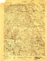
The Blackwater River and Chowan River define this Tidewater landscape on the border of Virginia and North Carolina. The city of Franklin serves as a central hub, where the Seaboard Air Line RR and Atlantic and Danville RR converge. This 1950s revision of earlier planetable surveys reveals a deeply rural network of small crossroads like Maynards Crossroads and Carrsville, alongside institutional landmarks such as the Hayden High Sch and the VPI Research Sta.
Find a feature on this map
114 named features on this map. Tap any name to fly to it.
Don’t see what you’re looking for? This feature index may not catch every label — zoom into the map to look around manually.
Map Details
Editions of this 1957 Holland Map
This is the sole edition of this map. No revisions or reprints were ever made.
Other maps of this area

1906 · Beckford
USGS Topo · 1:48,000

1907 · Beckford
USGS Topo · 1:62,500

1908 · Winton
USGS Topo · 1:62,500

1919 · Smithfield
USGS Topo · 1:62,500

1919 · Suffolk
USGS Topo · 1:62,500

1919 · Homeville
USGS Topo · 1:48,000
1919 · Boykins
USGS Topo · 1:48,000

1920 · Holland
USGS Topo · 1:62,500

1920 · Ivor
USGS Topo · 1:62,500

1920 · Homeville
USGS Topo · 1:62,500