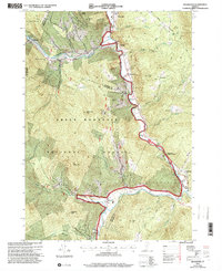
1997 Map of Rochester
USGS Topo · Published 2000About this map
White River and Tweed River valleys define the settlement patterns of this Vermont landscape during the late 1990s. The town of Rochester serves as a central hub, while smaller hamlets like Talcville, Emerson, and Pittsfield follow the narrow corridor between the steep ridges of the Green Mountain National Forest. The mapping of the CCC Camp Interpretive Site and the Peavine Interpretive Site highlights a focus on historical preservation and recreational land use, contrasting with the earlier industrial presence of Mines and various Gravel Pits found throughout the region.
Find a feature on this map
54 named features on this map. Tap any name to fly to it.
Don’t see what you’re looking for? This feature index may not catch every label — zoom into the map to look around manually.
Map Details
Editions of this 1997 Rochester Map
This is the sole edition of this map. No revisions or reprints were ever made.
Other maps of this area

1891 · Rutland
USGS Topo · 1:62,500

1893 · Rutland
USGS Topo · 1:62,500

1911 · Woodstock
USGS Topo · 1:62,500

1913 · Woodstock
USGS Topo · 1:62,500

1915 · Rochester
USGS Topo · 1:62,500

1917 · Rochester
USGS Topo · 1:62,500

1919 · Royalton
USGS Topo · 1:62,500

1924 · Randolph
USGS Topo · 1:48,000

1926 · Randolph
USGS Topo · 1:62,500

1943 · Woodstock
USGS Topo · 1:62,500