1949 Map of Rock Harbor
USGS Topo · Published 1949About this map
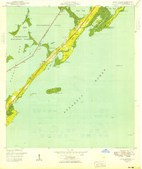
Key Largo's upper stretch appears here during the late 1940s, revealing a string of small settlements and navigational landmarks before the massive post-war development of the Florida Keys. Small communities like Newport and Rock Harbor are clustered along the main road, while St Margarets Ch and Getman Memorial Ch provide evidence of early social centers for residents. The western waters of Florida Bay and Buttonwood Sound are protected by the Everglades National Park boundary, emphasizing the region's conservation history.
Find a feature on this map
29 named features on this map. Tap any name to fly to it.
Don’t see what you’re looking for? This feature index may not catch every label — zoom into the map to look around manually.
Map Details
Editions of this 1949 Rock Harbor Map
2 editions found
Historical Maps of Key Largo Through Time
371 maps found

1921 Sugar Loaf Key
Monroe County, FL

1943 Bay Keys
Monroe County, FL

1943 Boca Chica
Monroe County, FL

1943 Cottrell Key
Monroe County, FL

1943 Saddlebunch Keys
Monroe County, FL

1943 Snipe Keys
Monroe County, FL

1943 Sugarloaf Key
Monroe County, FL

1947 Garden Cove
Monroe County, FL

1947 Rock Harbor
Monroe County, FL

1949 Card Sound
Monroe County, FL

1949 Garden Cove
Monroe County, FL

1949 Rock Harbor
Monroe County, FL

1956 Card Sound
Monroe County, FL

1963 Cottrell Key
Monroe County, FL

1968 Saddlebunch Keys
Monroe County, FL

1971 Boca Chica Key
Monroe County, FL

1971 Crawl Key
Monroe County, FL

1971 Dry Tortugas
Monroe County, FL

1971 Grassy Key
Monroe County, FL

1971 Long Key
Monroe County, FL

1971 Lower Matecumbe Key
Monroe County, FL

1971 Marquesas Keys East
Monroe County, FL

1971 Marquesas Keys West
Monroe County, FL

1971 Plantation Key
Monroe County, FL

1971 Upper Matecumbe Key
Monroe County, FL

1972 Bamboo Key
Monroe County, FL

1972 Bay Keys
Monroe County, FL

1972 Big Boy Lake
Monroe County, FL

1972 Buchanan Keys
Monroe County, FL

1972 Calusa Keys
Monroe County, FL

1972 Clive Key
Monroe County, FL

1972 Content Keys
Monroe County, FL

1972 Cottrell Key
Monroe County, FL

1972 East Bahia Honda Key
Monroe County, FL

1972 East Bahia Honda Key NE
Monroe County, FL

1972 Harney River
Monroe County, FL

1972 Horseshoe Keys
Monroe County, FL

1972 Indian Camp Creek
Monroe County, FL

1972 Joe Bay
Monroe County, FL

1972 Lake Ingraham East
Monroe County, FL

1972 Lake Ingraham West
Monroe County, FL

1972 Loggerhead Key
Monroe County, FL

1972 Lostmans Trail
Monroe County, FL

1972 Pelican Keys
Monroe County, FL

1972 Saddlebunch Keys
Monroe County, FL

1972 Sandy Key
Monroe County, FL

1972 Sawyer Key
Monroe County, FL

1972 Schooner Bank
Monroe County, FL

1972 Sevenmile Bridge
Monroe County, FL

1972 Shark Point
Monroe County, FL

1972 Shark River Island
Monroe County, FL

1972 Snipe Keys
Monroe County, FL

1972 Sugarloaf Key
Monroe County, FL

1972 Summerland Key
Monroe County, FL

1972 Tarpon Bay
Monroe County, FL

1972 Whitewater Bay East
Monroe County, FL

1972 Whitewater Bay West
Monroe County, FL

1973 Alligator Bay
Monroe County, FL

1973 Big Lostmans Bay
Monroe County, FL

1973 Flamingo
Monroe County, FL

1973 Lostmans River Ranger Station
Monroe County, FL

1973 Pavilion Key
Monroe County, FL

1973 Plover Key
Monroe County, FL

1981 Cape Sable
Monroe County, FL

1983 Dry Tortugas
Monroe County, FL

1983 Islamorada
Monroe County, FL

1988 Card Sound
Monroe County, FL

1989 Dry Tortugas
Monroe County, FL

1994 Card Sound
Monroe County, FL

2012 Alligator Bay
Monroe County, FL

2012 Bamboo Key
Monroe County, FL

2012 Bay Keys
Monroe County, FL

2012 Big Boy Lake
Monroe County, FL

2012 Big Lostmans Bay
Monroe County, FL

2012 Boca Chica Key
Monroe County, FL

2012 Buchanan Keys
Monroe County, FL

2012 Calusa Keys
Monroe County, FL

2012 Card Sound
Monroe County, FL

2012 Clive Key
Monroe County, FL

2012 Content Keys
Monroe County, FL

2012 Cottrell Key
Monroe County, FL

2012 Crawl Key
Monroe County, FL

2012 Dry Tortugas
Monroe County, FL

2012 Dry Tortugas OE E
Monroe County, FL

2012 Dry Tortugas OE SE
Monroe County, FL

2012 Dry Tortugas OE S
Monroe County, FL

2012 East Bahia Honda Key
Monroe County, FL

2012 East Bahia Honda Key NE
Monroe County, FL

2012 Flamingo
Monroe County, FL

2012 Garden Cove
Monroe County, FL

2012 Grassy Key
Monroe County, FL

2012 Harney River
Monroe County, FL

2012 Horseshoe Keys
Monroe County, FL

2012 Indian Camp Creek
Monroe County, FL

2012 Joe Bay
Monroe County, FL

2012 Key Lois
Monroe County, FL

2012 Lake Ingraham East
Monroe County, FL

2012 Lake Ingraham West
Monroe County, FL

2012 Long Key
Monroe County, FL

2012 Lostmans River Ranger Station
Monroe County, FL

2012 Lostmans Trail
Monroe County, FL

2012 Lower Matecumbe Key
Monroe County, FL

2012 Marquesas Keys East
Monroe County, FL

2012 Marquesas Keys West
Monroe County, FL

2012 Pavilion Key
Monroe County, FL

2012 Pavilion Key OE W
Monroe County, FL

2012 Pelican Keys
Monroe County, FL

2012 Plantation Key
Monroe County, FL

2012 Plover Key
Monroe County, FL

2012 Rock Harbor
Monroe County, FL

2012 Saddlebunch Keys
Monroe County, FL

2012 Sandy Key
Monroe County, FL

2012 Sawyer Key
Monroe County, FL

2012 Schooner Bank
Monroe County, FL

2012 Sevenmile Bridge
Monroe County, FL

2012 Shark Point
Monroe County, FL

2012 Shark River Island
Monroe County, FL

2012 Snipe Keys
Monroe County, FL

2012 Sugarloaf Key
Monroe County, FL

2012 Summerland Key
Monroe County, FL

2012 Tarpon Bay
Monroe County, FL

2012 Upper Matecumbe Key
Monroe County, FL

2012 Whitewater Bay East
Monroe County, FL

2012 Whitewater Bay West
Monroe County, FL

2015 Alligator Bay
Monroe County, FL

2015 Bamboo Key
Monroe County, FL

2015 Bay Keys
Monroe County, FL

2015 Big Boy Lake
Monroe County, FL

2015 Big Lostmans Bay
Monroe County, FL

2015 Boca Chica Key
Monroe County, FL

2015 Buchanan Keys
Monroe County, FL

2015 Calusa Keys
Monroe County, FL

2015 Card Sound
Monroe County, FL

2015 Clive Key
Monroe County, FL

2015 Content Keys
Monroe County, FL

2015 Cottrell Key
Monroe County, FL

2015 Crawl Key
Monroe County, FL

2015 Dry Tortugas
Monroe County, FL

2015 Dry Tortugas OE E
Monroe County, FL

2015 Dry Tortugas OE SE
Monroe County, FL

2015 Dry Tortugas OE S
Monroe County, FL

2015 East Bahia Honda Key
Monroe County, FL

2015 East Bahia Honda Key NE
Monroe County, FL

2015 Flamingo
Monroe County, FL

2015 Garden Cove
Monroe County, FL

2015 Grassy Key
Monroe County, FL

2015 Harney River
Monroe County, FL

2015 Horseshoe Keys
Monroe County, FL

2015 Indian Camp Creek
Monroe County, FL

2015 Joe Bay
Monroe County, FL

2015 Key Lois
Monroe County, FL

2015 Lake Ingraham East
Monroe County, FL

2015 Lake Ingraham West
Monroe County, FL

2015 Long Key
Monroe County, FL

2015 Lostmans River Ranger Station
Monroe County, FL

2015 Lostmans Trail
Monroe County, FL

2015 Lower Matecumbe Key
Monroe County, FL

2015 Marquesas Keys East
Monroe County, FL

2015 Marquesas Keys West
Monroe County, FL

2015 Pavilion Key
Monroe County, FL

2015 Pavilion Key OE W
Monroe County, FL

2015 Pelican Keys
Monroe County, FL

2015 Plantation Key
Monroe County, FL

2015 Plover Key
Monroe County, FL

2015 Rock Harbor
Monroe County, FL

2015 Saddlebunch Keys
Monroe County, FL

2015 Sandy Key
Monroe County, FL

2015 Sawyer Key
Monroe County, FL

2015 Schooner Bank
Monroe County, FL

2015 Sevenmile Bridge
Monroe County, FL

2015 Shark Point
Monroe County, FL

2015 Shark River Island
Monroe County, FL

2015 Snipe Keys
Monroe County, FL

2015 Sugarloaf Key
Monroe County, FL

2015 Summerland Key
Monroe County, FL

2015 Tarpon Bay
Monroe County, FL

2015 Upper Matecumbe Key
Monroe County, FL

2015 Whitewater Bay East
Monroe County, FL

2015 Whitewater Bay West
Monroe County, FL

2018 Alligator Bay
Monroe County, FL

2018 Bamboo Key
Monroe County, FL

2018 Bay Keys
Monroe County, FL

2018 Big Boy Lake
Monroe County, FL

2018 Big Lostmans Bay
Monroe County, FL

2018 Boca Chica Key
Monroe County, FL

2018 Buchanan Keys
Monroe County, FL

2018 Calusa Keys
Monroe County, FL

2018 Card Sound
Monroe County, FL

2018 Clive Key
Monroe County, FL

2018 Content Keys
Monroe County, FL

2018 Cottrell Key
Monroe County, FL

2018 Crawl Key
Monroe County, FL

2018 Dry Tortugas
Monroe County, FL

2018 Dry Tortugas OE E
Monroe County, FL

2018 Dry Tortugas OE SE
Monroe County, FL

2018 Dry Tortugas OE S
Monroe County, FL

2018 East Bahia Honda Key
Monroe County, FL

2018 East Bahia Honda Key NE
Monroe County, FL

2018 Flamingo
Monroe County, FL

2018 Garden Cove
Monroe County, FL

2018 Grassy Key
Monroe County, FL

2018 Harney River
Monroe County, FL

2018 Horseshoe Keys
Monroe County, FL

2018 Indian Camp Creek
Monroe County, FL

2018 Joe Bay
Monroe County, FL

2018 Key Lois
Monroe County, FL

2018 Lake Ingraham East
Monroe County, FL

2018 Lake Ingraham West
Monroe County, FL

2018 Long Key
Monroe County, FL

2018 Lostmans River Ranger Station
Monroe County, FL

2018 Lostmans Trail
Monroe County, FL

2018 Lower Matecumbe Key
Monroe County, FL

2018 Marquesas Keys East
Monroe County, FL

2018 Marquesas Keys West
Monroe County, FL

2018 Pavilion Key
Monroe County, FL

2018 Pavilion Key OE W
Monroe County, FL

2018 Pelican Keys
Monroe County, FL

2018 Plantation Key
Monroe County, FL

2018 Plover Key
Monroe County, FL

2018 Rock Harbor
Monroe County, FL

2018 Saddlebunch Keys
Monroe County, FL

2018 Sandy Key
Monroe County, FL

2018 Sawyer Key
Monroe County, FL

2018 Schooner Bank
Monroe County, FL

2018 Sevenmile Bridge
Monroe County, FL

2018 Shark Point
Monroe County, FL

2018 Shark River Island
Monroe County, FL

2018 Snipe Keys
Monroe County, FL

2018 Sugarloaf Key
Monroe County, FL

2018 Summerland Key
Monroe County, FL

2018 Tarpon Bay
Monroe County, FL

2018 Upper Matecumbe Key
Monroe County, FL

2018 Whitewater Bay East
Monroe County, FL

2018 Whitewater Bay West
Monroe County, FL

2021 Alligator Bay
Monroe County, FL

2021 Bamboo Key
Monroe County, FL

2021 Bay Keys
Monroe County, FL

2021 Big Boy Lake
Monroe County, FL

2021 Big Lostmans Bay
Monroe County, FL

2021 Boca Chica Key
Monroe County, FL

2021 Buchanan Keys
Monroe County, FL

2021 Calusa Keys
Monroe County, FL

2021 Card Sound
Monroe County, FL

2021 Clive Key
Monroe County, FL

2021 Content Keys
Monroe County, FL

2021 Cottrell Key
Monroe County, FL

2021 Crawl Key
Monroe County, FL

2021 Dry Tortugas
Monroe County, FL

2021 Dry Tortugas OE E
Monroe County, FL

2021 Dry Tortugas OE SE
Monroe County, FL

2021 Dry Tortugas OE S
Monroe County, FL

2021 East Bahia Honda Key
Monroe County, FL

2021 East Bahia Honda Key NE
Monroe County, FL

2021 Flamingo
Monroe County, FL

2021 Garden Cove
Monroe County, FL

2021 Grassy Key
Monroe County, FL

2021 Harney River
Monroe County, FL

2021 Horseshoe Keys
Monroe County, FL

2021 Indian Camp Creek
Monroe County, FL

2021 Joe Bay
Monroe County, FL

2021 Key Lois
Monroe County, FL

2021 Lake Ingraham East
Monroe County, FL

2021 Lake Ingraham West
Monroe County, FL

2021 Long Key
Monroe County, FL

2021 Lostmans River Ranger Station
Monroe County, FL

2021 Lostmans Trail
Monroe County, FL

2021 Lower Matecumbe Key
Monroe County, FL

2021 Marquesas Keys East
Monroe County, FL

2021 Marquesas Keys West
Monroe County, FL

2021 Pavilion Key
Monroe County, FL

2021 Pavilion Key OE W
Monroe County, FL

2021 Pelican Keys
Monroe County, FL

2021 Plantation Key
Monroe County, FL

2021 Plover Key
Monroe County, FL

2021 Rock Harbor
Monroe County, FL

2021 Saddlebunch Keys
Monroe County, FL

2021 Sandy Key
Monroe County, FL

2021 Sawyer Key
Monroe County, FL

2021 Schooner Bank
Monroe County, FL

2021 Sevenmile Bridge
Monroe County, FL

2021 Shark Point
Monroe County, FL

2021 Shark River Island
Monroe County, FL

2021 Snipe Keys
Monroe County, FL

2021 Sugarloaf Key
Monroe County, FL

2021 Summerland Key
Monroe County, FL

2021 Tarpon Bay
Monroe County, FL

2021 Upper Matecumbe Key
Monroe County, FL

2021 Whitewater Bay East
Monroe County, FL

2021 Whitewater Bay West
Monroe County, FL

2023 Tarpon Bay
Monroe County, FL

2024 Alligator Bay
Monroe County, FL

2024 Bamboo Key
Monroe County, FL

2024 Bay Keys
Monroe County, FL

2024 Big Boy Lake
Monroe County, FL

2024 Big Lostmans Bay
Monroe County, FL

2024 Boca Chica Key
Monroe County, FL

2024 Buchanan Keys
Monroe County, FL

2024 Calusa Keys
Monroe County, FL

2024 Card Sound
Monroe County, FL

2024 Clive Key
Monroe County, FL

2024 Content Keys
Monroe County, FL

2024 Cottrell Key
Monroe County, FL

2024 Crawl Key
Monroe County, FL

2024 Dry Tortugas
Monroe County, FL

2024 Dry Tortugas OE E
Monroe County, FL

2024 Dry Tortugas OE SE
Monroe County, FL

2024 Dry Tortugas OE S
Monroe County, FL

2024 East Bahia Honda Key
Monroe County, FL

2024 East Bahia Honda Key NE
Monroe County, FL

2024 Flamingo
Monroe County, FL

2024 Garden Cove
Monroe County, FL

2024 Grassy Key
Monroe County, FL

2024 Harney River
Monroe County, FL

2024 Horseshoe Keys
Monroe County, FL

2024 Indian Camp Creek
Monroe County, FL

2024 Joe Bay
Monroe County, FL

2024 Key Lois
Monroe County, FL

2024 Lake Ingraham East
Monroe County, FL

2024 Lake Ingraham West
Monroe County, FL

2024 Long Key
Monroe County, FL

2024 Lostmans River Ranger Station
Monroe County, FL

2024 Lostmans Trail
Monroe County, FL

2024 Lower Matecumbe Key
Monroe County, FL

2024 Marquesas Keys East
Monroe County, FL

2024 Marquesas Keys West
Monroe County, FL

2024 Pavilion Key
Monroe County, FL

2024 Pavilion Key OE W
Monroe County, FL

2024 Pelican Keys
Monroe County, FL

2024 Plantation Key
Monroe County, FL

2024 Plover Key
Monroe County, FL

2024 Rock Harbor
Monroe County, FL

2024 Saddlebunch Keys
Monroe County, FL

2024 Sandy Key
Monroe County, FL

2024 Sawyer Key
Monroe County, FL

2024 Schooner Bank
Monroe County, FL

2024 Sevenmile Bridge
Monroe County, FL

2024 Shark Point
Monroe County, FL

2024 Shark River Island
Monroe County, FL

2024 Snipe Keys
Monroe County, FL

2024 Sugarloaf Key
Monroe County, FL

2024 Summerland Key
Monroe County, FL

2024 Tarpon Bay
Monroe County, FL

2024 Upper Matecumbe Key
Monroe County, FL

2024 Whitewater Bay East
Monroe County, FL

2024 Whitewater Bay West
Monroe County, FL

2025 Alligator Bay
Monroe County, FL

2025 Bamboo Key
Monroe County, FL

2025 Bay Keys
Monroe County, FL

2025 Content Keys
Monroe County, FL

2025 Cottrell Key
Monroe County, FL

2025 Dry Tortugas
Monroe County, FL

2025 Dry Tortugas OE E
Monroe County, FL

2025 Dry Tortugas OE SE
Monroe County, FL

2025 Dry Tortugas OE S
Monroe County, FL

2025 East Bahia Honda Key
Monroe County, FL

2025 East Bahia Honda Key NE
Monroe County, FL

2025 Horseshoe Keys
Monroe County, FL

2025 Lake Ingraham East
Monroe County, FL

2025 Lake Ingraham West
Monroe County, FL

2025 Lostmans River Ranger Station
Monroe County, FL

2025 Marquesas Keys East
Monroe County, FL

2025 Marquesas Keys West
Monroe County, FL

2025 Pavilion Key
Monroe County, FL

2025 Pavilion Key OE W
Monroe County, FL

2025 Plover Key
Monroe County, FL

2025 Sandy Key
Monroe County, FL

2025 Sawyer Key
Monroe County, FL

2025 Shark Point
Monroe County, FL

2025 Shark River Island
Monroe County, FL

2025 Snipe Keys
Monroe County, FL

2025 Sugarloaf Key
Monroe County, FL