
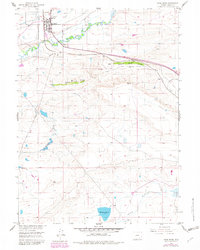
1955 Map of Rock River
USGS Topo · Published 1957About this map
Rock River serves as the focal point of this mid-century survey, situated where the Union Pacific railroad and the Lincoln Highway converge along the banks of Rock Creek. The landscape is defined by the prominent escarpments of Upper Pine Ridge and Lower Pine Ridge, which overlook a region shaped by transportation and resource extraction. Evidence of local industry is scattered throughout the township, including a Coal Mine and several Gravel Pits near the city boundary.
Find a feature on this map
24 named features on this map. Tap any name to fly to it.
Don’t see what you’re looking for? This feature index may not catch every label — zoom into the map to look around manually.
Map Details
Editions of this 1955 Rock River Map
2 editions found
Other maps of this area

1915 · Como Ridge
USGS Topo · 1:48,000

1918 · Como Ridge
USGS Topo · 1:62,500

1954 · Cheyenne
USGS Topo · 1:250,000

1954 · Rawlins
USGS Topo · 1:250,000

1955 · Big Judson
USGS Topo · 1:24,000

1955 · Cooper Lake South
USGS Topo · 1:24,000

1955 · Cooper Lake North
USGS Topo · 1:24,000

1955 · Cannonball Cut
USGS Topo · 1:24,000

1955 · Wilcox
USGS Topo · 1:24,000

1958 · Rawlins
USGS Topo · 1:250,000