
1941 Map of Rockland
USGS Topo · Published 1941About this map
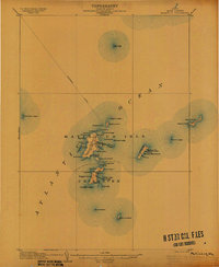
Rockland and its busy harbor anchor this coastal Maine survey, which illustrates the region's transition into the early 1940s. The map reveals the intricate maritime infrastructure of Midcoast Maine, from the long finger of the Rockland Breakwater Lighthouse protecting the inner harbor to the prominent Owls Head Lighthouse marking the southern entrance. Beyond the industrial and commercial core, the landscape is dotted with smaller coastal villages such as Rockport and South Thomaston, alongside more isolated settlements like Wattons Mill and Willis Corners.
Find a feature on this map
157 named features on this map. Tap any name to fly to it.
Don’t see what you’re looking for? This feature index may not catch every label — zoom into the map to look around manually.
Map Details
Editions of this 1941 Rockland Map
This is the sole edition of this map. No revisions or reprints were ever made.
Other maps of this area

1902 · Castine
USGS Topo · 1:62,500

1904 · Castine
USGS Topo · 1:62,500

1904 · Vinalhaven
USGS Topo · 1:62,500

1904 · Monhegan
USGS Topo · 1:62,500

1904 · Tenants Harbor
USGS Topo · 1:62,500

1904 · Rockland
USGS Topo · 1:62,500

1905 · Penobscot Bay
USGS Topo · 1:125,000
1906 · Matinicus
USGS Topo · 1:62,500

1906 · Tennant Harbor
USGS Topo · 1:62,500

1906 · Monhegan
USGS Topo · 1:62,500