1964 Map of Rockport
USGS Topo · Published 1983About this map
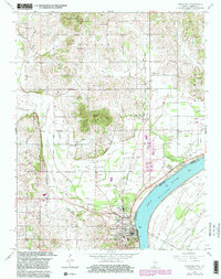
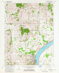
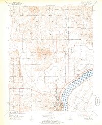
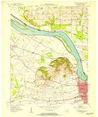
The Ohio River bend defines the southern boundary of this mid-century survey, where the town of Rockport serves as a vital riverfront hub. The landscape is marked by the distinct elevations of Fisher Knobs and Coal Knobs, rising above the surrounding agricultural fields and drainages like Honey Creek and Huffman Ditch. An extensive network of Oil Wells peppered across the center of the sheet indicates the era's active petroleum extraction industry.
Find a feature on this map
41 named features on this map. Tap any name to fly to it.
Don’t see what you’re looking for? This feature index may not catch every label — zoom into the map to look around manually.
Map Details
Editions of this 1964 Rockport Map
2 editions found
Other maps of this area

1900 · St Meinrad
USGS Topo · 1:62,500

1900 · De Gonia Springs
USGS Topo · 1:62,500

1901 · Owensboro
USGS Topo · 1:62,500

1902 · Ditney
USGS Topo · 1:125,000

1902 · Degonia Springs
USGS Topo · 1:62,500
1903 · St. Meinrad
USGS Topo · 1:62,500

1903 · Tell City
USGS Topo · 1:62,500
1952 · Owensboro East
USGS Topo · 1:24,000
1952 · Rockport
USGS Topo · 1:24,000
1952 · Owensboro West
USGS Topo · 1:24,000