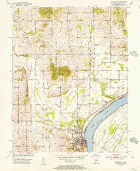
1952 Map of Rockport
USGS Topo · Published 1953About this map
Rockport anchors the riverfront in the early 1950s, serving as a hub where the Southern railroad meets the wide arc of the Ohio River. This survey reveals a landscape shaped by both early industry and local community, featuring numerous Oil Wells scattered near Rock Hill and the prominent Coal Knobs rising above the bottomlands. For local historians, the sheet is dense with markers of civic life, from the Lincoln Pioneer Village and the County Infirmary on the outskirts of the main settlement to small rural schools like Silverdale Sch.
Find a feature on this map
42 named features on this map. Tap any name to fly to it.
Don’t see what you’re looking for? This feature index may not catch every label — zoom into the map to look around manually.
Map Details
Editions of this 1952 Rockport Map
2 editions found
Other maps of this area

1900 · St Meinrad
USGS Topo · 1:62,500

1900 · De Gonia Springs
USGS Topo · 1:62,500

1901 · Owensboro
USGS Topo · 1:62,500

1902 · Ditney
USGS Topo · 1:125,000

1902 · Degonia Springs
USGS Topo · 1:62,500

1903 · St. Meinrad
USGS Topo · 1:62,500

1903 · Tell City
USGS Topo · 1:62,500

1952 · Owensboro East
USGS Topo · 1:24,000

1952 · Rockport
USGS Topo · 1:24,000

1952 · Owensboro West
USGS Topo · 1:24,000