
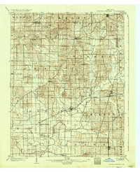
1902 Map of Degonia Springs
USGS Topo · Published 1902About this map
Degonia Springs and Ash Iron Springs serve as central landmarks in this Southwestern Indiana landscape at the dawn of the twentieth century. The map reveals a transition from the rugged drainage of the South Fork Patoka River in the north to the more level terrain around Little Pigeon Creek to the south. The rural economy is tied closely to the Southern railroad, particularly the Evansville Division and Rockport Branch, which connect smaller nodes like Tennyson, Gentryville, and Chrisney.
Find a feature on this map
46 named features on this map. Tap any name to fly to it.
Don’t see what you’re looking for? This feature index may not catch every label — zoom into the map to look around manually.
Map Details
Editions of this 1902 Degonia Springs Map
2 editions found
Other maps of this area

1900 · St Meinrad
USGS Topo · 1:62,500

1900 · De Gonia Springs
USGS Topo · 1:62,500

1901 · Owensboro
USGS Topo · 1:62,500

1902 · Ditney
USGS Topo · 1:125,000

1902 · Boonville
USGS Topo · 1:62,500

1903 · St. Meinrad
USGS Topo · 1:62,500

1903 · Velpen
USGS Topo · 1:62,500

1903 · Petersburg
USGS Topo · 1:62,500

1903 · Tell City
USGS Topo · 1:62,500

1905 · Newburg
USGS Topo · 1:62,500