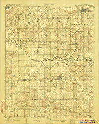
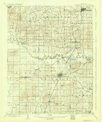
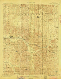
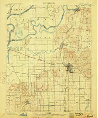
1903 Map of Petersburg
USGS Topo · Published 1903About this map
The White River and the winding Patoka River define the landscape of Pike and Gibson Counties at the turn of the century. This survey records a transitional industrial era, most notably preserving the route of the Erie Canal (Abandoned) as it cuts through Dongola. The southern portion of the quadrangle is punctuated by hills such as Kennedy Hill and Wilson Hill, while the rail infrastructure of the Southern R. R. and the Evansville and Indianapolis R. R. supports the region's growing coal interests. Local mining activity is prominent east of Oakland City, with the Massey Mine, Klondike Mine, and Ingle Mine all clearly marked. These early pits and shafts represent the beginning of the coal industry that would reshape this part of southern Indiana. Many small settlements, including Coats Springs and Wheeling, are shown connected by a dense network of country roads before the arrival of modern highways.
Find a feature on this map
86 named features on this map. Tap any name to fly to it.
Don’t see what you’re looking for? This feature index may not catch every label — zoom into the map to look around manually.
Map Details
Editions of this 1903 Petersburg Map
2 editions found
Other maps of this area

1900 · De Gonia Springs
USGS Topo · 1:62,500

1901 · Princeton
USGS Topo · 1:62,500

1901 · Haubstadt
USGS Topo · 1:62,500

1902 · Ditney
USGS Topo · 1:125,000

1902 · Degonia Springs
USGS Topo · 1:62,500

1902 · Boonville
USGS Topo · 1:62,500
1903 · Velpen
USGS Topo · 1:62,500

1903 · Haubstadt
USGS Topo · 1:62,500
1903 · Princeton
USGS Topo · 1:62,500

1903 · Patoka
USGS Topo · 1:125,000