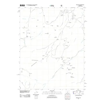
2011 Map of Rockvale
USGS Topo · Published 2011About this map
The legacy of Colorado's coal mining industry is written across the landscape of Rockvale and the surrounding canyons. This topographical record details a dense network of extraction sites, ranging from the Canon Imperial Mine in the northeast to the Monarch Number 4 Mine and Canon Monarch Mine further south. The map illustrates how settlements like Coal Creek and the small enclave at Radiant Camp developed in direct proximity to these industrial operations, often tucked into the valleys carved by Oak Creek and Newlin Creek. Beyond the primary shafts like the Rockvale Mine, the terrain is punctuated by dozens of smaller or family-named prospects, including the Double Dick Mines and Black Diamond Mine. The convergence of Middle Fork Coal Creek Canyon and West Fork Coal Creek Canyon near Stony Point highlights the geological complexity that once supported this region's extractive economy.
Find a feature on this map
92 named features on this map. Tap any name to fly to it.
Don’t see what you’re looking for? This feature index may not catch every label — zoom into the map to look around manually.
Map Details
Editions of this 2011 Rockvale Map
This is the sole edition of this map. No revisions or reprints were ever made.
Other maps of this area

1889 · Canon City
USGS Topo · 1:125,000

1892 · Canon City
USGS Topo · 1:125,000

1954 · Mount Tyndall
USGS Topo · 1:24,000

1954 · Pueblo
USGS Topo · 1:250,000

1957 · Pueblo
USGS Topo · 1:250,000

1958 · Pueblo
USGS Topo · 1:250,000

1959 · Florence
USGS Topo · 1:24,000
1959 · Canon City
USGS Topo · 1:24,000

1959 · Rockvale
USGS Topo · 1:24,000

1959 · Royal Gorge
USGS Topo · 1:62,500