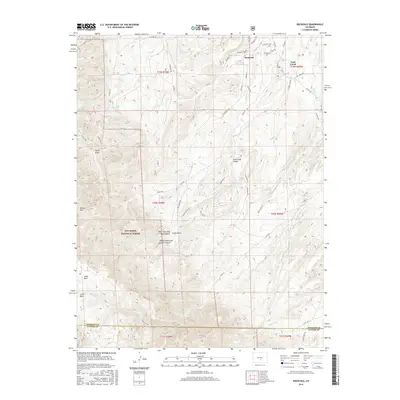
2016 Map of Rockvale
USGS Topo · Published 2016About this map
Rockvale sits at the northern edge of this high-desert landscape where the high plains meet the eastern foothills of the Rockies. The terrain is defined by deep incisions such as Coal Creek Canyon and West Fork Coal Creek Canyon, showing a transition from the coal-bearing gulches to the high-elevation slopes of the San Isabel National Forest. Local navigation relies on a network of backcountry routes like Co RD 143 and the Stultz Trail, which provide access to significant landmarks including Round Mtn and Stony Point.
Find a feature on this map
69 named features on this map. Tap any name to fly to it.
Don’t see what you’re looking for? This feature index may not catch every label — zoom into the map to look around manually.
Map Details
Editions of this 2016 Rockvale Map
This is the sole edition of this map. No revisions or reprints were ever made.
Other maps of this area

1889 · Canon City
USGS Topo · 1:125,000

1892 · Canon City
USGS Topo · 1:125,000

1954 · Mount Tyndall
USGS Topo · 1:24,000

1954 · Pueblo
USGS Topo · 1:250,000

1957 · Pueblo
USGS Topo · 1:250,000

1958 · Pueblo
USGS Topo · 1:250,000

1959 · Florence
USGS Topo · 1:24,000
1959 · Canon City
USGS Topo · 1:24,000

1959 · Rockvale
USGS Topo · 1:24,000

1959 · Royal Gorge
USGS Topo · 1:62,500