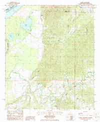
1986 Map of Rodney
USGS Topo · Published 1986About this map
Rodney stands as a focal point along the eastern bluffs of the Mississippi River, where the high ground of the loess hills meets the alluvial floodplain. This mid-1980s survey captures the landscape shortly after the designation of the Natchez Trace Parkway, which winds through the southern portion of the map near the confluence of the North Fork Coles Creek and South Fork Coles Creek. The geography is defined by a sharp contrast between the active Oil and Gas Fields in the uplands and the swampy lowlands of the river bend.
Find a feature on this map
32 named features on this map. Tap any name to fly to it.
Don’t see what you’re looking for? This feature index may not catch every label — zoom into the map to look around manually.
Map Details
Editions of this 1986 Rodney Map
This is the sole edition of this map. No revisions or reprints were ever made.
Other maps of this area

1909 · Delta Bridge
USGS Topo · 1:24,000

1909 · Lake Bruen
USGS Topo · 1:24,000

1921 · Natchez
USGS Topo · 1:48,000

1922 · Natchez
USGS Topo · 1:62,500

1939 · Lorman
USGS Topo · 1:62,500

1939 · Natchez
USGS Topo · 1:62,500

1939 · Locust Ridge
USGS Topo · 1:62,500

1953 · Natchez
USGS Topo · 1:250,000

1956 · Natchez
USGS Topo · 1:250,000

1958 · St. Joseph
USGS Topo · 1:62,500