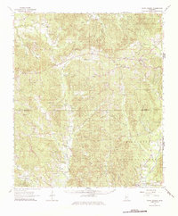
1963 Map of Union Church
USGS Topo · Published 1986About this map
The Homochitto National Forest encompasses much of this landscape along the border of Jefferson and Franklin Counties, where the headwaters of the Middle Fork Homochitto River and North Fork Coles Creek create a deeply dissected terrain. The namesake settlement of Union Church serves as a local hub, surrounded by a high density of family and community landmarks such as Knight Sch and the Hickory Block Cem. To the south, the industrial and transport corridor follows the Mississippi Central line, connecting the communities of Eddiceton, Kirby, and Quentin. This area is particularly rich in genealogical data, preserving the locations of numerous rural congregations and burial grounds like Ephesus Ch, Newman Cem, and the oddly named Drift Hotel, which sit alongside small creeks and branches that defined the early settlement patterns of the region.
Find a feature on this map
61 named features on this map. Tap any name to fly to it.
Don’t see what you’re looking for? This feature index may not catch every label — zoom into the map to look around manually.
Map Details
Editions of this 1963 Union Church Map
2 editions found
Other maps of this area

1939 · Lorman
USGS Topo · 1:62,500

1953 · Natchez
USGS Topo · 1:250,000

1956 · Natchez
USGS Topo · 1:250,000

1958 · St. Joseph
USGS Topo · 1:62,500

1959 · Natchez
USGS Topo · 1:250,000

1961 · Crosby
USGS Topo · 1:62,500

1962 · Fayette
USGS Topo · 1:62,500

1962 · Bude
USGS Topo · 1:62,500

1963 · Red Lick
USGS Topo · 1:24,000

1963 · Union Church
USGS Topo · 1:62,500