
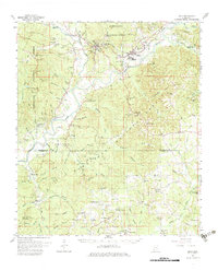
1962 Map of Bude
USGS Topo · Published 1964About this map
Meadville and Bude serve as the central hubs of this early 1960s survey, situated along the Central Mississippi River railroad line. The landscape is dominated by the dense timberlands of the Homochitto National Forest, which is crisscrossed by a complex network of waterways including the Homochitto River and its many tributaries like Caston Creek and Middle Fork Mississippi River. Local industry is clearly defined by the sprawling Bude Oil Field and West Bude Oil Field, alongside numerous active Gravel Pits that punctuate the terrain.
Find a feature on this map
115 named features on this map. Tap any name to fly to it.
Don’t see what you’re looking for? This feature index may not catch every label — zoom into the map to look around manually.
Map Details
Editions of this 1962 Bude Map
2 editions found
Other maps of this area

1953 · Natchez
USGS Topo · 1:250,000

1956 · Natchez
USGS Topo · 1:250,000

1959 · Natchez
USGS Topo · 1:250,000

1961 · Liberty
USGS Topo · 1:62,500

1961 · Crosby
USGS Topo · 1:62,500

1961 · Gloster
USGS Topo · 1:62,500

1962 · Fayette
USGS Topo · 1:62,500

1963 · Union Church
USGS Topo · 1:62,500

1972 · Smithdale
USGS Topo · 1:24,000

1972 · McCall Creek
USGS Topo · 1:24,000