
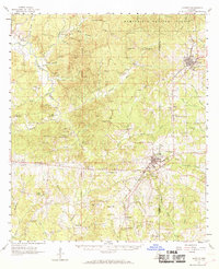
1961 Map of Gloster
USGS Topo · Published 1963About this map
Gloster and Centreville anchor the rail and road network of this Southwest Mississippi landscape in the early 1960s. The Illinois Central railroad cuts through the terrain, connecting these timber and agricultural centers to the broader region. To the north, the Homochitto National Forest covers much of the map, while the Buffalo River and its numerous tributaries, including Silver Creek and Jackson Creek, drain the countryside.
Find a feature on this map
88 named features on this map. Tap any name to fly to it.
Don’t see what you’re looking for? This feature index may not catch every label — zoom into the map to look around manually.
Map Details
Editions of this 1961 Gloster Map
2 editions found
Other maps of this area

1906 · Bayou Sara
USGS Topo · 1:125,000

1936 · Woodville
USGS Topo · 1:62,500

1939 · St. Francisville
USGS Topo · 1:62,500

1939 · Kingston
USGS Topo · 1:62,500

1941 · Woodland
USGS Topo · 1:31,680

1941 · Norwood
USGS Topo · 1:31,680

1941 · Lost Creek
USGS Topo · 1:31,680

1945 · Norwood
USGS Topo · 1:31,680

1945 · Lost Creek
USGS Topo · 1:31,680

1953 · Natchez
USGS Topo · 1:250,000