1945 Map of Norwood
USGS Topo · Published 1945About this map
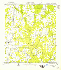
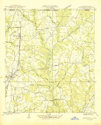
Norwood and Wilson serve as primary hubs along the Illinois Central (Yazoo and Mississippi Valley) railroad corridor, marking a landscape defined by its rural community structure in the mid-1940s. The area is heavily marked by local institutions like Brooks Chapel Sch & Ch, Morning Glory Ch, and the Industrial Training Sch near Clinton. The drainage pattern is complex, with the Comite River and its numerous tributaries such as Beecham Bayou Creek and Richland Creek carving through the terrain. This map captures the transition from the Mississippi-Louisiana border into East Feliciana Parish, showing a network of rural roads like State Highway 16 On that connected dispersed family farms and community centers such as Antioch Ch and Asbury Sch.
Find a feature on this map
39 named features on this map. Tap any name to fly to it.
Don’t see what you’re looking for? This feature index may not catch every label — zoom into the map to look around manually.
Map Details
Editions of this 1945 Norwood Map
This is the sole edition of this map. No revisions or reprints were ever made.