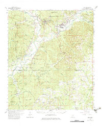
1962 Map of Bude
USGS Topo · Published 1983About this map
The Homochitto River and its intricate network of tributaries like the Middle Fork Homochitto River define this portion of the Homochitto National Forest. In the early 1960s, the region was characterized by the timber and petroleum industries, evidenced by the presence of the Bude Oil Field and the Illinois Central railroad corridor. The neighboring towns of Meadville and Bude serve as the primary hubs, with Meadville notably featuring a radio tower and Bude housing the Bude Lookout Tower.
Find a feature on this map
114 named features on this map. Tap any name to fly to it.
Don’t see what you’re looking for? This feature index may not catch every label — zoom into the map to look around manually.
Map Details
Editions of this 1962 Bude Map
2 editions found
Other maps of this area

1953 · Natchez
USGS Topo · 1:250,000

1956 · Natchez
USGS Topo · 1:250,000

1959 · Natchez
USGS Topo · 1:250,000

1961 · Liberty
USGS Topo · 1:62,500

1961 · Crosby
USGS Topo · 1:62,500

1961 · Gloster
USGS Topo · 1:62,500

1962 · Fayette
USGS Topo · 1:62,500

1962 · Bude
USGS Topo · 1:62,500

1963 · Union Church
USGS Topo · 1:62,500

1972 · Smithdale
USGS Topo · 1:24,000