
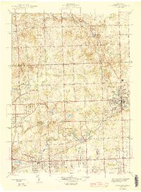
1943 Map of Romeo
USGS Topo · Published 1965About this map
The village of Romeo serves as the focal point for this survey of northeast Michigan, where the agricultural plains meet the rolling glacial topography of Twombly Mtn and Pleasant Knoll. The landscape is a complex network of wetlands and small glacial lakes, including Fisher Lake, Hidden Lake, and the winding Stony Creek, which supported local industry at the Clifton Mill site. This 1940s landscape is densely peppered with rural institutions, from the Simpson Park Camp Ground to numerous neighborhood schoolhouses such as Bruce Center Sch and Sikes Sch, reflecting the community structure of the Bruce and Washington townships before significant suburban expansion. The Grand Trunk Western railroad cuts through the eastern portion of the sheet, anchoring the regional economy of the day to the village center. Genealogists will find particular value in the clearly marked rural burial grounds, including Mccafferty Cem and Bruce Cem.
Find a feature on this map
55 named features on this map. Tap any name to fly to it.
Don’t see what you’re looking for? This feature index may not catch every label — zoom into the map to look around manually.
Map Details
Editions of this 1943 Romeo Map
This is the sole edition of this map. No revisions or reprints were ever made.
Other maps of this area

1908 · Rochester
USGS Topo · 1:62,500

1912 · Mt Clemens
USGS Topo · 1:62,500

1914 · Armada
USGS Topo · 1:62,500

1928 · Armada
USGS Topo · 1:62,500

1929 · Mt Clemens
USGS Topo · 1:62,500

1936 · Rochester
USGS Topo · 1:31,680

1936 · Washington
USGS Topo · 1:31,680

1936 · Waldenburg
USGS Topo · 1:31,680

1943 · Lake Orion
USGS Topo · 1:24,000
1945 · Rochester
USGS Topo · 1:24,000
Featured Places
- Washington Charter Township, MI
- Oakland Charter Township, MI
- Addison Township, MI
- Romeo, MI
- Clifton Mill, Washington Charter Township