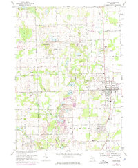
1968 Map of Romeo
USGS Topo · Published 1974About this map
Romeo serves as a major hub for the northern Macomb County region in this late 1960s study, displaying a grid of established streets and the Grand Trunk Western railroad corridor. The surrounding landscape in Bruce and Washington townships is characterized by a dense concentration of small glacial lakes, including Cusick Lake, Thorington Lake, and Nowlan Lake, many of which supported early industry and social life. Evidence of the area's agricultural and rural history is found at Clifton Mill and the Grange Hall along 31 Mile Road, while the numerous Gravel Pits indicate active local extraction. Religious and educational landmarks like the Capuchin Retreat and Iley Sch appear alongside several family-named burial grounds, such as McCafferty Cem and Brabb Cem, providing a detailed view of the community's settlement patterns before further suburban expansion.
Find a feature on this map
81 named features on this map. Tap any name to fly to it.
Don’t see what you’re looking for? This feature index may not catch every label — zoom into the map to look around manually.
Map Details
Editions of this 1968 Romeo Map
2 editions found
Other maps of this area

1908 · Rochester
USGS Topo · 1:62,500

1912 · Mt Clemens
USGS Topo · 1:62,500

1914 · Armada
USGS Topo · 1:62,500

1928 · Armada
USGS Topo · 1:62,500

1929 · Mt Clemens
USGS Topo · 1:62,500

1936 · Rochester
USGS Topo · 1:31,680

1936 · Washington
USGS Topo · 1:31,680

1936 · Waldenburg
USGS Topo · 1:31,680

1943 · Lake Orion
USGS Topo · 1:24,000

1943 · Romeo
USGS Topo · 1:24,000
Featured Places
- Washington Charter Township, MI
- Oakland Charter Township, MI
- Addison Township, MI
- Romeo, MI
- Clifton Mill, Washington Charter Township