
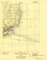
1908 Map of Rochester
USGS Topo · Published 1908About this map
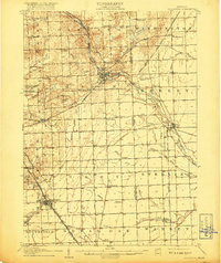
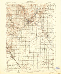
Rochester serves as the central hub on this 1908 survey, situated at the confluence of Paint Creek and the Clinton River. The landscape reveals a complex transportation network transitioning from traditional rail to electric power, evidenced by the Detroit and Lake Orion Electric Ry and the Detroit and Pontiac Electric Ry paralleling existing lines like the Michigan Central RR. Rural life is meticulously documented through local institutions such as Oakland Church, the Stone Shop, and numerous district schoolhouses including Snell School and Hubbel School. Settlements like Big Beaver, Stony Creek, and Birmingham anchor the surrounding townships, while the topography rises toward Bald Mtn in the northwest. This era of Michigan's development is characterized by high-density agricultural drainage, seen in features like Sprague Ditch and Gibson Drain, supporting a landscape of small farmsteads and growing village centers.
Find a feature on this map
74 named features on this map. Tap any name to fly to it.
Don’t see what you’re looking for? This feature index may not catch every label — zoom into the map to look around manually.
Map Details
Editions of this 1908 Rochester Map
3 editions found
Other maps of this area

1905 · Wayne
USGS Topo · 1:62,500

1905 · Detroit
USGS Topo · 1:62,500
1905 · Grosse Pointe
USGS Topo · 1:62,500

1907 · Pontiac
USGS Topo · 1:62,500

1912 · Mt Clemens
USGS Topo · 1:62,500

1912 · Wayne
USGS Topo · 1:62,500
1914 · Armada
USGS Topo · 1:62,500

1918 · Detroit
USGS Topo · 1:62,500
1918 · Grosse Pointe
USGS Topo · 1:62,500

1924 · Detroit
USGS Topo · 1:62,500