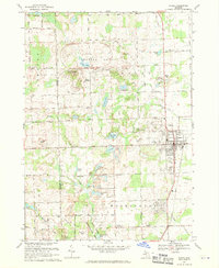
1968 Map of Romeo
USGS Topo · Published 1970About this map
The village of Romeo serves as a focal point in this late 1960s landscape, positioned at the edge of a transitioning rural environment where the glacial geography of Macomb and Oakland Counties is clearly visible. The terrain is defined by a dense network of kettle lakes and drains, including East Mill Lake, Cusick Lake, and Thorington Lake. A massive Proving Ground occupies the northwestern corner near Twombly Mtn, while the southern reaches showcase the early development of the Stony Creek Metropolitan Park around Stony Creek Lake.
Find a feature on this map
65 named features on this map. Tap any name to fly to it.
Don’t see what you’re looking for? This feature index may not catch every label — zoom into the map to look around manually.
Map Details
Editions of this 1968 Romeo Map
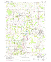
2 editions found
Other maps of this area

1908 · Rochester
USGS Topo · 1:62,500

1912 · Mt Clemens
USGS Topo · 1:62,500

1914 · Armada
USGS Topo · 1:62,500

1928 · Armada
USGS Topo · 1:62,500

1929 · Mt Clemens
USGS Topo · 1:62,500

1936 · Rochester
USGS Topo · 1:31,680

1936 · Washington
USGS Topo · 1:31,680

1936 · Waldenburg
USGS Topo · 1:31,680

1943 · Lake Orion
USGS Topo · 1:24,000

1943 · Romeo
USGS Topo · 1:24,000
Featured Places
- Washington Charter Township, MI
- Oakland Charter Township, MI
- Addison Township, MI
- Romeo, MI
- Clifton Mill, Washington Charter Township