2023 Map of Roosevelt
USGS Topo · Published 2023About this map
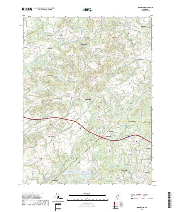
Roosevelt and its surrounding Monmouth County townships are defined by a complex network of headwater streams and small mill ponds that have shaped the region's development for generations. The landscape is characterized by the branching waters of Assunpink Creek, Rocky Brook, and the Millstone River, which historically provided the power for early local industry at sites like Francis Mills. This 2023 survey documents a mix of agricultural land and suburban growth, interspersed with significant local landmarks including the Old Yellow Meeting House Cem and Emleys Hill Cem. Several notable water bodies, such as Perrineville Lake and Prospertown Lake, serve as focal points for the surrounding rural communities of Clarksburg, Perrineville, and Red Valley. The map also captures the path of the Interstate 195 corridor as it cuts through the center of these long-established settlements, illustrating the modern infrastructure that connects this portion of New Jersey.
Find a feature on this map
47 named features on this map. Tap any name to fly to it.
Don’t see what you’re looking for? This feature index may not catch every label — zoom into the map to look around manually.
Map Details
Editions of this 2023 Roosevelt Map
This is the sole edition of this map. No revisions or reprints were ever made.
Historical Maps of Red Valley Through Time
4 maps found
Featured Locations
- Jackson Township, NJ
- East Windsor Township, NJ
- Manalapan Township, NJ
- Millstone Township, NJ
- Freehold Township, NJ