2023 Map of Roscoe
USGS Topo · Published 2023About this map
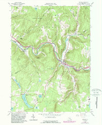
Beaver Kill and Willowemoc Creek converge at Roscoe, a famed junction for trout fishing in the Catskill region. This 2023 survey illustrates the modern layout of several small riverfront communities, including Cooks Falls, Rockland, and Butternut Grove, all situated along the valley floor near the Delaware and Sullivan County boundary. The topography is defined by high ridges like Stadel Mountain and Morton Hill, which separate the river valleys from high-elevation water bodies such as Tennanah Lake and Lake Florence.
Find a feature on this map
85 named features on this map. Tap any name to fly to it.
Don’t see what you’re looking for? This feature index may not catch every label — zoom into the map to look around manually.
Map Details
Editions of this 2023 Roscoe Map
This is the sole edition of this map. No revisions or reprints were ever made.