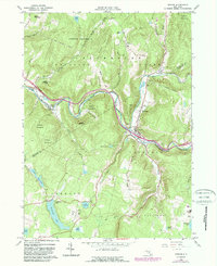
1965 Map of Roscoe
USGS Topo · Published 1989About this map
Beaver Kill and Willowemoc Creek converge near the town of Roscoe, a significant junction within the sprawling Catskill Park. This mid-1960s survey captures the area’s identity as a hub for trout fishing and mountain recreation, featuring numerous lodges and seasonal camps like Camp Highmount. The landscape is dominated by steep-walled hollows such as Lanfield Hollow and Parker Cook Hollow, with much of the territory protected within the state Forest Preserve. Large bodies of water including Tennanah Lake, Lake Florence, and Muskoday Lake dot the southern highlands, while the subterranean West Delaware Aqueduct cuts a straight path deep beneath the ridges. Small settlements like Cooks Falls, Rockland, and Butternut Grove follow the narrow river valleys, accompanied by local landmarks such as the Riverview Cemetery and multiple golf courses.
Find a feature on this map
43 named features on this map. Tap any name to fly to it.
Don’t see what you’re looking for? This feature index may not catch every label — zoom into the map to look around manually.
Map Details
Editions of this 1965 Roscoe Map
3 editions found
Other maps of this area

1920 · Long Eddy
USGS Topo · 1:62,500

1921 · Long Eddy
USGS Topo · 1:48,000

1921 · Livingston Manor
USGS Topo · 1:62,500

1922 · Andes
USGS Topo · 1:62,500

1923 · Long Eddy
USGS Topo · 1:62,500

1923 · Walton
USGS Topo · 1:48,000

1923 · Livingston Manor
USGS Topo · 1:62,500

1924 · Andes
USGS Topo · 1:62,500

1925 · Walton
USGS Topo · 1:62,500

1943 · Honesdale
USGS Topo · 1:125,000