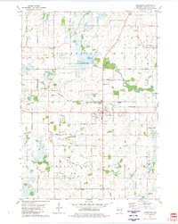
1980 Map of Rosendale
USGS Topo · Published 1981About this map
The village of Rosendale serves as the central hub of this 1980 survey, where the Chicago and North Western railroad crosses the landscape. The geography is characterized by the West Branch Fond du Lac River and several industrial features, including a sewage disposal site and an Industrial Waste Pond near the village core. This map captures the agricultural and early industrial infrastructure of Fond du Lac County, from the village green at Wm N Taylor Park to the outlying hamlets of West Rosendale and Rosendale Center. For those researching local families, the map identifies several rural landmarks like St Marys Ch and cemeteries such as N Eldorado Cem and Rosendale North Cem. The presence of numerous Gravel Pits and a Radio Tower reflect the mid-century development of the region's utilities and resources.
Find a feature on this map
41 named features on this map. Tap any name to fly to it.
Don’t see what you’re looking for? This feature index may not catch every label — zoom into the map to look around manually.
Map Details
Editions of this 1980 Rosendale Map
This is the sole edition of this map. No revisions or reprints were ever made.
Other maps of this area

1916 · Ripon
USGS Topo · 1:48,000

1918 · Ripon
USGS Topo · 1:62,500

1955 · Waupun
USGS Topo · 1:62,500

1955 · Fox Lake
USGS Topo · 1:62,500

1956 · Ripon
USGS Topo · 1:62,500

1956 · Rosendale
USGS Topo · 1:62,500

1957 · Madison
USGS Topo · 1:250,000

1960 · Madison
USGS Topo · 1:250,000

1975 · Waupun NW
USGS Topo · 1:24,000
1975 · Waupun NE
USGS Topo · 1:24,000