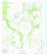
1963 Map of Rosser
USGS Topo · Published 1963About this map
Rosser sits at a strategic bend where the East Fork Trinity River joins the main channel, anchoring a landscape shaped by both natural hydrology and mid-century water management. The area is defined by a complex network of sloughs and lateral sites, including Lateral Site No 12 and the Rosser-Trinidad Lateral Site No 1, which reflect local efforts to control the river's path across the Hillside Terrace. Rural life in the 1960s is centered around family and faith, evidenced by scattered country churches like Mt Olive Ch, Cottonwood Ch, and Bridges Ch, alongside the Scurry-Rosser Sch.
Find a feature on this map
40 named features on this map. Tap any name to fly to it.
Don’t see what you’re looking for? This feature index may not catch every label — zoom into the map to look around manually.
Map Details
Editions of this 1963 Rosser Map
2 editions found
Other maps of this area

1891 · Dallas
USGS Topo · 1:125,000

1893 · Dallas
USGS Topo · 1:125,000

1954 · Dallas
USGS Topo · 1:250,000

1956 · Ennis
USGS Topo · 1:62,500

1956 · Kaufman
USGS Topo · 1:62,500

1958 · Dallas
USGS Topo · 1:250,000

1959 · India
USGS Topo · 1:24,000

1959 · Seagoville
USGS Topo · 1:62,500

1960 · Grays Prairie
USGS Topo · 1:24,000

1962 · Ennis East
USGS Topo · 1:24,000