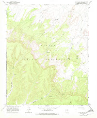
1968 Map of Rough Rock NW
USGS Topo · Published 1972About this map
The Navajo Indian Reservation landscape within the Black Mesa region is defined by deep drainage systems and prominent geological formations. In the late 1960s, this area near Rough Rock was characterized by traditional livestock support infrastructure, including several named water sources like Yellow Man Spring, Red Tree Spring, and Sand Spring. The high desert terrain is punctuated by significant landmarks such as Red Peak and the sharp spire of The Needle near Toh De Kaish. Evidence of mineral exploration appears in the southern portion of the quadrangle with identified Mines and a Drill Hole near the Navajo and Apache county line. Travel through this environment relied on specialized routes, including the Hajibai Trail and the seasonally difficult Pain in the Back Canyon, while Warpath Valley provided a natural corridor through the mesas.
Find a feature on this map
23 named features on this map. Tap any name to fly to it.
Don’t see what you’re looking for? This feature index may not catch every label — zoom into the map to look around manually.
Map Details
Editions of this 1968 Rough Rock NW Map
This is the sole edition of this map. No revisions or reprints were ever made.
Other maps of this area

1883 · Marsh Pass
USGS Topo · 1:250,000

1892 · Marsh Pass
USGS Topo · 1:250,000

1892 · Canyon De Chelly
USGS Topo · 1:250,000

1954 · Shiprock
USGS Topo · 1:250,000

1956 · Marble Canyon
USGS Topo · 1:250,000

1958 · Shiprock
USGS Topo · 1:250,000

1959 · Shiprock
USGS Topo · 1:250,000

1959 · Marble Canyon
USGS Topo · 1:250,000

1961 · Marble Canyon
USGS Topo · 1:250,000
1968 · Hole In Rock Valley
USGS Topo · 1:24,000