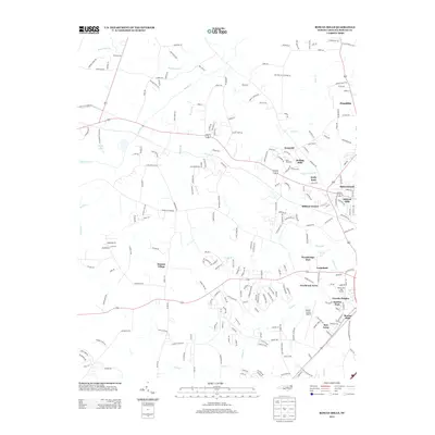
2013 Map of Rowan Mills
USGS Topo · Published 2013About this map
Rowan Mills and the western suburbs of Salisbury are defined by a complex network of residential developments and aviation infrastructure in this 2013 survey. The landscape transitions from the dense street grids of Milford Hills and Lincoln Heights to the sprawling grounds of the Rowan County Airport. Significant creek systems, including Second Cr and Grants Cr, drain the region, influencing the placement of older rural routes and modern residential clusters like Watson Village.
Find a feature on this map
225 named features on this map. Tap any name to fly to it.
Don’t see what you’re looking for? This feature index may not catch every label — zoom into the map to look around manually.
Map Details
Editions of this 2013 Rowan Mills Map
This is the sole edition of this map. No revisions or reprints were ever made.
Other maps of this area

1893 · Statesville
USGS Topo · 1:125,000

1950 · Churchland
USGS Topo · 1:24,000

1951 · Churchland
USGS Topo · 1:24,000

1953 · Charlotte
USGS Topo · 1:250,000

1954 · Charlotte
USGS Topo · 1:250,000

1960 · Charlotte
USGS Topo · 1:250,000

1962 · Charlotte
USGS Topo · 1:250,000
1962 · Salisbury
USGS Topo · 1:24,000
1962 · Rockwell
USGS Topo · 1:24,000

1969 · Cooleemee
USGS Topo · 1:24,000