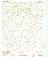
1984 Map of Rowena
USGS Topo · Published 1984About this map
The Colorado River carves a winding path through the northern reaches of this Runnels County landscape, creating a distinct topographical boundary marked by the Red Bank bluffs and several contributing streams. The settlement of Rowena serves as the primary hub of activity in the southern section, centered around the Atchison Topeka and Santa Fe railroad corridor. This mid-1980s data highlights a rural Texas community defined by its water sources and transportation lines, including the prominent Rowena Spire Rowena WT landmark and a local Cem. Outside the town center, the terrain is shaped by a network of drainage systems like Indian Creek, Rocky Creek, and Valley Creek. Of particular interest to local historians is the noted Caliche Grave and several scattered Gravel Pits, indicating the intersection of geology and early local development.
Find a feature on this map
13 named features on this map. Tap any name to fly to it.
Don’t see what you’re looking for? This feature index may not catch every label — zoom into the map to look around manually.
Map Details
Editions of this 1984 Rowena Map
This is the sole edition of this map. No revisions or reprints were ever made.
Other maps of this area

1891 · Hayrick
USGS Topo · 1:125,000

1892 · Ballinger
USGS Topo · 1:125,000

1894 · Hayrick
USGS Topo · 1:125,000

1921 · Baker Flat
USGS Topo · 1:31,680

1921 · Hatchel
USGS Topo · 1:31,680

1921 · Lowake
USGS Topo · 1:31,680

1921 · Maverick
USGS Topo · 1:31,680

1921 · Quarry Creek
USGS Topo · 1:31,680

1921 · Spur Creek
USGS Topo · 1:31,680

1921 · Rowena
USGS Topo · 1:31,680