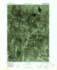
1975 Map of Royalston
USGS Topo · Published 1981About this map
Royalston and its surrounding hill-town settlements are captured in this mid-1970s orthophotograph, which uses aerial imagery to reveal the dense forest cover and hydrologic patterns of northern Worcester County. The landscape is defined by the flow of the East Branch Tully River southward into Tully Lake and the winding path of the Millers River near South Royalston. These waterways once powered the small-scale industries that sustained the villages of West Royalston and Tully. The map provides a unique visual record of land use before more modern development, showing the clearings for farms and homes against the stark dark shapes of Laurel Lake and Sportsman Pond. It is a vital resource for understanding the spatial relationship between the historic village centers and the rugged New England terrain that shaped their growth.
Find a feature on this map
9 named features on this map. Tap any name to fly to it.
Don’t see what you’re looking for? This feature index may not catch every label — zoom into the map to look around manually.
Map Details
Editions of this 1975 Royalston Map
This is the sole edition of this map. No revisions or reprints were ever made.
Other maps of this area

1887 · Warwick
USGS Topo · 1:62,500

1887 · Winchendon
USGS Topo · 1:62,500

1889 · Warwick
USGS Topo · 1:62,500

1890 · Winchendon
USGS Topo · 1:62,500

1894 · Winchendon
USGS Topo · 1:62,500

1894 · Warwick
USGS Topo · 1:62,500

1898 · Monadnock
USGS Topo · 1:62,500

1898 · Keene
USGS Topo · 1:62,500

1932 · Warwick
USGS Topo · 1:48,000

1932 · Winchendon
USGS Topo · 1:48,000