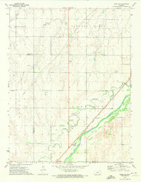
1972 Map of Rozel SE
USGS Topo · Published 1974About this map
Arkansas River bottomlands define the southeastern corner of this Pawnee County landscape, where the Atchison Topeka and Santa Fe railroad corridor follows the valley floor alongside the river's winding course. This era shows the rural intersection of industrial activity and agricultural persistence, marked by active Oil Wells in the west and a Gravel Pit near the riverbank.
Find a feature on this map
17 named features on this map. Tap any name to fly to it.
Don’t see what you’re looking for? This feature index may not catch every label — zoom into the map to look around manually.
Map Details
Editions of this 1972 Rozel SE Map
This is the sole edition of this map. No revisions or reprints were ever made.
Other maps of this area

1889 · Larned
USGS Topo · 1:125,000

1889 · Kinsley
USGS Topo · 1:125,000

1891 · Larned
USGS Topo · 1:125,000

1892 · Kinsley
USGS Topo · 1:125,000

1894 · Kinsley
USGS Topo · 1:125,000

1955 · Great Bend
USGS Topo · 1:250,000

1955 · Pratt
USGS Topo · 1:250,000

1957 · Great Bend
USGS Topo · 1:250,000

1958 · Great Bend
USGS Topo · 1:250,000

1959 · Pratt
USGS Topo · 1:250,000