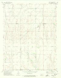
1972 Map of Rozel SW
USGS Topo · Published 1974About this map
Ss Peter & Paul Ch stands as a focal point for the rural community along the southern border of this 1970s survey. The landscape is characterized by the townships of Sawmill, Keysville, Logan, and Jackson, spanning the boundary between Pawnee and Edwards Counties. This era of the Kansas plains reflects an established agricultural grid increasingly intersected by industrial infrastructure, marked by the presence of Gas Wells, Oil Wells, and several Pipelines cutting across the terrain. Local history is anchored by the Salem Cem and Lutheran Cem, while a prominent Radio Tower in the eastern section serves as a modern landmark. The map documents the subtle shift from a purely agrarian economy to one integrating energy extraction during the early 1970s.
Find a feature on this map
12 named features on this map. Tap any name to fly to it.
Don’t see what you’re looking for? This feature index may not catch every label — zoom into the map to look around manually.
Map Details
Editions of this 1972 Rozel SW Map
This is the sole edition of this map. No revisions or reprints were ever made.
Other maps of this area

1889 · Larned
USGS Topo · 1:125,000

1889 · Kinsley
USGS Topo · 1:125,000

1891 · Larned
USGS Topo · 1:125,000

1892 · Ness
USGS Topo · 1:125,000

1892 · Kinsley
USGS Topo · 1:125,000

1892 · Spearville
USGS Topo · 1:125,000

1894 · Spearville
USGS Topo · 1:125,000

1894 · Kinsley
USGS Topo · 1:125,000

1894 · Ness
USGS Topo · 1:125,000

1955 · Great Bend
USGS Topo · 1:250,000