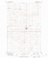
1972 Map of Rudyard
USGS Topo · Published 1975About this map
Rudyard serves as the central hub of this 1970s Hi-Line landscape, situated along the Burlington Northern railroad. The town layout is clearly defined, featuring an Athletic Field, Sewage Disposal Ponds, and a series of Storage Bins that underscore the area's agricultural foundations. The surrounding terrain is characterized by the winding path of Hingham Coulee, which drains toward the seasonal waters of Hingham Lake in the northeast.
Find a feature on this map
12 named features on this map. Tap any name to fly to it.
Don’t see what you’re looking for? This feature index may not catch every label — zoom into the map to look around manually.
Map Details
Editions of this 1972 Rudyard Map
This is the sole edition of this map. No revisions or reprints were ever made.
Other maps of this area

1919 · Big Sandy
USGS Topo · 1:125,000

1919 · Alma
USGS Topo · 1:125,000

1920 · Gildford
USGS Topo · 1:125,000

1943 · Gildford
USGS Topo · 1:125,000

1954 · Shelby
USGS Topo · 1:250,000

1958 · Shelby
USGS Topo · 1:250,000

1969 · Gildford NW
USGS Topo · 1:24,000

1969 · Hingham
USGS Topo · 1:24,000

1969 · Fourteenmile Coulee NW
USGS Topo · 1:24,000

1970 · Rocky Coulee
USGS Topo · 1:24,000