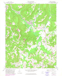
1972 Map of Rupert
USGS Topo · Published 1982About this map
Rupert serves as the central hub of this Greenbrier County survey, situated at the confluence of Big Clear Creek and the Meadow River. The landscape reveals a mix of mountain terrain and industrial activity, with Little Sewell Mountain rising to the west and multiple strip mines operating near McRoss and Hines. Transportation and local commerce are defined by the Chesapeake and Ohio railroad corridor, which follows the river valleys connecting small settlements like Kessler and Shawyers Crossing.
Find a feature on this map
42 named features on this map. Tap any name to fly to it.
Don’t see what you’re looking for? This feature index may not catch every label — zoom into the map to look around manually.
Map Details
Editions of this 1972 Rupert Map
2 editions found
Other maps of this area

1887 · Hinton
USGS Topo · 1:125,000

1889 · Nicholas
USGS Topo · 1:125,000

1891 · Nicholas
USGS Topo · 1:125,000

1892 · Hinton
USGS Topo · 1:125,000

1901 · Nicholas
USGS Topo · 1:125,000

1912 · Meadow Creek
USGS Topo · 1:48,000

1914 · Winona
USGS Topo · 1:48,000

1915 · Meadow Creek
USGS Topo · 1:62,500

1916 · Winona
USGS Topo · 1:62,500

1918 · Richwood
USGS Topo · 1:62,500