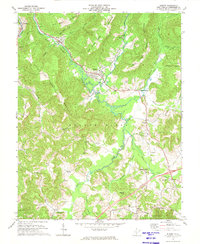
1972 Map of Rupert
USGS Topo · Published 1974About this map
Rupert serves as the central hub of this Greenbrier County landscape, where the Nicholas Fayette and Greenbrier railroad tracks wind through the valley of the Meadow River. In the early 1970s, the area's economic character is defined by a mix of agriculture and industry, visible in the Strip Mine operations scattered across the hills and the presence of the Rainelle Airpark. Small settlements like Hines, McRoss, and Kessler dot the northern reaches, while the southern terrain is marked by the distinct Meadow Bluff district.
Find a feature on this map
73 named features on this map. Tap any name to fly to it.
Don’t see what you’re looking for? This feature index may not catch every label — zoom into the map to look around manually.
Map Details
Editions of this 1972 Rupert Map
2 editions found
Other maps of this area

1887 · Hinton
USGS Topo · 1:125,000

1889 · Nicholas
USGS Topo · 1:125,000

1891 · Nicholas
USGS Topo · 1:125,000

1892 · Hinton
USGS Topo · 1:125,000

1901 · Nicholas
USGS Topo · 1:125,000

1912 · Meadow Creek
USGS Topo · 1:48,000

1914 · Winona
USGS Topo · 1:48,000

1915 · Meadow Creek
USGS Topo · 1:62,500

1916 · Winona
USGS Topo · 1:62,500

1918 · Richwood
USGS Topo · 1:62,500