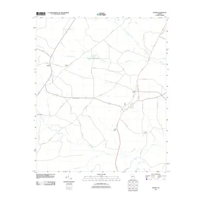
2011 Map of Rupert
USGS Topo · Published 2011About this map
Bloodworth Cemetery and Sand Bethel Cemetery anchor the rural landscape of Taylor County in this early 21st-century record of the Georgia interior. The area is defined by a network of local routes like Ed Davis Rd and Jaye Rd, which connect small communities such as Charing and Rupert. Water resources are central to the region's topography, evidenced by Garretts Pond Dam and Rogers Mill Dam, alongside the winding paths of Rambulette Creek and Whitewater Creek. The Rupert Post Office serves as a central landmark for local residents, while the Beulah Lookout Tower stands as a prominent point of interest in the surrounding woodland. This survey provides a clear view of the family-named landmarks and historical burial grounds, including Prosperity Cemetery, that continue to define this pocket of the Deep South.
Find a feature on this map
43 named features on this map. Tap any name to fly to it.
Don’t see what you’re looking for? This feature index may not catch every label — zoom into the map to look around manually.
Map Details
Editions of this 2011 Rupert Map
This is the sole edition of this map. No revisions or reprints were ever made.
Other maps of this area

1955 · Phenix City
USGS Topo · 1:250,000

1957 · Phenix City
USGS Topo · 1:250,000

1958 · Phenix City
USGS Topo · 1:250,000

1971 · Rupert
USGS Topo · 1:24,000

1971 · Ideal South
USGS Topo · 1:24,000

1971 · Ideal North
USGS Topo · 1:24,000

1971 · Ellaville North
USGS Topo · 1:24,000
1971 · Butler West
USGS Topo · 1:24,000

1971 · Tazewell South
USGS Topo · 1:24,000
1971 · Butler East
USGS Topo · 1:24,000