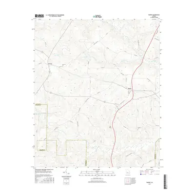
2017 Map of Rupert
USGS Topo · Published 2017About this map
Charing and Rupert anchor this agricultural landscape in central Georgia, where Taylor, Schley, and Macon counties converge. The terrain is defined by a dense network of watercourses, including Whitewater Cr, Rambulette Cr, and Cedar Cr, which likely supported early industry as evidenced by Rogers Mill Lake. The settlement pattern follows established routes like the Americus Hwy and State Rte 127, with numerous family-named roads such as Henry Barrow Rd and D Harris Farm Rd reflecting deep local lineage. For genealogists, the map preserves the exact locations of significant burial grounds including Bloodworth Cem, Sand Bethel Cem, and Prosperity Cem, which serve as landmarks for the surrounding rural communities. Small water bodies like Garretts Pond dot the creek valleys, marking the transition from upland farms to bottomland drainages.
Find a feature on this map
52 named features on this map. Tap any name to fly to it.
Don’t see what you’re looking for? This feature index may not catch every label — zoom into the map to look around manually.
Map Details
Editions of this 2017 Rupert Map
This is the sole edition of this map. No revisions or reprints were ever made.
Other maps of this area

1955 · Phenix City
USGS Topo · 1:250,000

1957 · Phenix City
USGS Topo · 1:250,000

1958 · Phenix City
USGS Topo · 1:250,000

1971 · Rupert
USGS Topo · 1:24,000

1971 · Ideal South
USGS Topo · 1:24,000

1971 · Ideal North
USGS Topo · 1:24,000

1971 · Ellaville North
USGS Topo · 1:24,000
1971 · Butler West
USGS Topo · 1:24,000

1971 · Tazewell South
USGS Topo · 1:24,000
1971 · Butler East
USGS Topo · 1:24,000