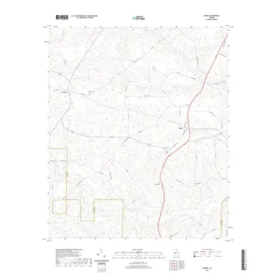
2020 Map of Rupert
USGS Topo · Published 2020About this map
Rupert and Charing anchor this agricultural landscape in Taylor County, where the terrain is defined by the winding paths of Whitewater Cr and its many tributaries. The area's rural history is preserved through scattered family and community burial grounds, including Bloodworth Cem north of Charing and Sand Bethel Cem further south. The drainage patterns of Coney Br and Rambulette Cr dictate the layout of the local road network, which connects these small settlements to surrounding Macon and Schley counties. Along the eastern edge, Garretts Pond provides a notable hydrologic feature amid the rolling elevation. The map details a transit-oriented corridor where the Americus Hwy and State Rte 127 intersect at Rupert, reflecting the long-standing role of these routes in moving timber and farm goods through the Georgia interior.
Find a feature on this map
55 named features on this map. Tap any name to fly to it.
Don’t see what you’re looking for? This feature index may not catch every label — zoom into the map to look around manually.
Map Details
Editions of this 2020 Rupert Map
This is the sole edition of this map. No revisions or reprints were ever made.
Other maps of this area

1955 · Phenix City
USGS Topo · 1:250,000

1957 · Phenix City
USGS Topo · 1:250,000

1958 · Phenix City
USGS Topo · 1:250,000

1971 · Rupert
USGS Topo · 1:24,000

1971 · Ideal South
USGS Topo · 1:24,000

1971 · Ideal North
USGS Topo · 1:24,000

1971 · Ellaville North
USGS Topo · 1:24,000
1971 · Butler West
USGS Topo · 1:24,000

1971 · Tazewell South
USGS Topo · 1:24,000
1971 · Butler East
USGS Topo · 1:24,000