
1915 Map of Russell
USGS Topo · Published 1958About this map
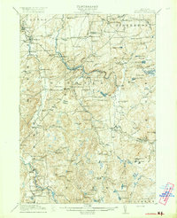
Grass River and the Little River carve through this North Country landscape, where early 20th-century settlement was defined by a dense network of local school districts and family-named crossroads. The town of Russell serves as a central hub, surrounded by smaller hamlets like Stellaville and Marshville. This survey preserves the location of numerous one-room schoolhouses, such as Porter Hill School and Silver Hill School, which were the social anchors of these rural communities.
Find a feature on this map
135 named features on this map. Tap any name to fly to it.
Don’t see what you’re looking for? This feature index may not catch every label — zoom into the map to look around manually.
Map Details
Editions of this 1915 Russell Map
This is the sole edition of this map. No revisions or reprints were ever made.
Other maps of this area

1904 · Ogdensburg
USGS Topo · 1:62,500

1905 · Ogdensburg
USGS Topo · 1:62,500

1908 · Potsdam
USGS Topo · 1:62,500

1910 · Canton
USGS Topo · 1:62,500

1911 · Canton
USGS Topo · 1:62,500

1913 · Lake Bonaparte
USGS Topo · 1:62,500

1915 · Gouverneur
USGS Topo · 1:62,500

1916 · Lake Bonaparte
USGS Topo · 1:62,500

1916 · Oswegatchie
USGS Topo · 1:62,500
1918 · Russell
USGS Topo · 1:62,500